| Carps among the Spratlys 南沙群岛的争战 The risk that almost comical regional competition in the South China Sea turns serious 关于中国南海近乎可笑的区域争斗开始升级 Mar 10th 2011 | from the print edition  YET again rival claimants to little specks of rock, sand and coral in the South China Sea are losing their tempers. The Philippines is incensed about an incident on March 2nd when, it says, two Chinese patrol boats threatened to ram a ship conducting a survey at Reed Bank, off its island of Palawan. On March 4th Vietnam also protested to China, about military exercises in waters it claims. Most probably these tiffs will blow over, as usual, long before anybody gets hurt. Yet the risks are mounting that a random incident in a bewildering array of quarrels may escalate into conflict, if only because no prospect exists of a settlement. 又一次对中国南海星罗棋布的岩礁、沙石和珊瑚礁的所属权的争论开始变得激烈起来。对于3月2日发生的事件,菲律宾表示非常不满,其声称2艘中国巡逻船威胁撞击一艘菲律宾船只,该船正在菲律宾岛屿巴拉望附近指挥调查里礼乐滩[1]。4日,越南也对中国在其声明所有的水域进行军事演习表示抗议。一如往常,这些争执很有可能在造成人员伤亡之前就得以平息。然而,经过这一系列让人头晕的争吵后,危机逐渐攀升到随便一个小冲突就可能导致上升为战争,因为大和解的未来似乎不可能存在。 That is partly because the sea is entangled in so many separate disputes. China and Vietnam claim sovereignty over the Paracel island chain, from which China evicted Vietnam in 1974, in the dying days of the Vietnam war. Taiwan―because it is the "Republic of China"―mirrors China's claim. The same three parties also contest the Spratly archipelago, to the south. But in the south Malaysia, the Philippines and Brunei also have partial claims. 造成这一局面一部分是因为这片海域集结了如此众多的不同纠纷。中国和越南宣称领海分界线为西沙群岛,由此,自1974年――越南战争最后的日子――中国开始驱逐越南。而台湾――"中华共和国"――也和中国一样宣称对西沙的主权。三方也就更南边的南沙群岛展开争夺,不过南部的马来西亚、菲律宾和文莱也声称对其拥有部分主权。 Some of these arguments might in theory be solvable under the 1982 United Nations Convention of the Law of the Sea (UNCLOS). In 2009, for example, Malaysia and Vietnam made a joint submission, showing where they thought their claims lay, based on their continental shelves. China, however, objected to that submission and tabled its own map, with nine dotted lines outlining its claim. Joined up, these lines give China almost the whole sea. There seems no basis for this in UNCLOS. But China points to a map in use since the Republic of China published it during the Chinese civil war in the 1940s and says that, until quite recently, nobody minded. Indonesia, in turn, objected to China's objection, since its claim encroached on Indonesian waters, too. 有些争论也许可以依照1982年颁布的联合国公约海洋法(UNCLOS)来解决。比如在2009年,马来西亚和越南发表了一份联合意见,表明他们认为自己的要求建立在其大陆架之上。然而中国却反对这个意见并绘制了自己的地图,由9条点状岛屿构成的岛链勾勒出中国所宣称的版图。这些线条几乎包括了整个海域。UNCLOS似乎并没有支持这一做法的基础。不过中国指出,自从中华共和国二十世纪四十年代的解放战争以来,这样的地图一直在使用,而直到不久之前,都没有人对此表示不满。反过来印度尼西亚对中国的异议提出反对,因为中方的声明也侵犯了印方的水域。 According to American officials, China last year began talking of its claims in the South China Sea as a "core" national interest, which would put it on a par with Tibet and Taiwan. In return, America has proclaimed its own "national interest", citing the importance of the freedom of navigation and of overflight. Neither is under immediate threat. China and America, however, have long disagreed about whether America's armed forces have the right to conduct manoeuvres within other countries' 200-mile exclusive economic zones (EEZs), and to spy on them even from inside their (12-mile) territorial waters. Two years ago America complained when Chinese vessels harassed a surveillance ship, the USNS Impeccable, in the South China Sea south of the Chinese island-province of Hainan. America's vociferous involvement, notably at a regional security forum in Hanoi last July, was welcomed at the time by most of the ten members of the Association of South-East Asian Nations (ASEAN). China, though, fumed at America's unrealistic offer of "mediation". 美国官方指出,中国自去年起开始将南中国海上升为"核心"国家利益问题,与台湾问题、西藏问题比肩。作为回应,美国将行海自由和飞越领空自由的重要性作为自己的"国家利益"。两者都没有受到直接威胁。然而,中国和美国就美国军方是否有权在他国200英里专属经济区(EEZs)内进行军事演习,以及在他国12英里领海范围内进行侦查活动的问题一直没能达成一致。两年前,美国抱怨中国船只干扰美国侦查舰无畏号在海南以南的南中国海的侦查活动。美国大张旗鼓地卷入在当时受到了东南亚国家联盟(东盟)十名成员国中大多数国家的欢迎,尤其是在去年七月河内地区安全论坛期间。不过中国对美国不切实际地企图"调停"大为不满。 Yet another dispute divides China and ASEAN. These two parties reached a common "Declaration on the Conduct of Parties in the South China Sea" (DoC) in 2002 in an attempt to minimise the risk of conflict. But efforts to turn this into a formal and binding code have gone nowhere. China argues that ASEAN has no role in territorial issues. It prefers to pick off rival claimants one by one. ASEAN argues that its own charter obliges members to consult, as they do before each working group on the code of conduct, the next one of which is due soon. Another difficulty for the DoC is that Taiwan is not a party. Though Taiwan occupies only one Spratly islet, it is the biggest, now boasting a long runway. 还有其它的争论分化中国和东盟。为了减少冲突发生的可能,中国和东盟在2002年达成了"南中国海各方管理公告"(DoC)。但这些努力并未变成正式的有约束力的准则。中国认为,东盟无权干预领土问题。她更倾向于一个一个消灭对手。东盟则认为,其章程有责任责成各成员国进行磋商,并且在各工作小组根据行为准则工作之前就要完成,而下一个工作小组即将展开工作。"公告"的另一个问题是,台湾并不是一个参与国。虽然台湾只拥有南沙群岛的一个岛屿,但这个岛是面积最大的,并拥有长长的延伸范围。  Optimists argue that the DoC has at least helped keep tensions down. Indeed, since 1988, when China and Vietnam clashed near the Spratlys, there have been no serious armed flare-ups. Tension rose in 1995, when China was found to have built on Mischief Reef, claimed by the Philippines. Fishermen are sometimes locked up for encroaching on another country's claim. But the risk of escalation into conflict has seemed limited. 乐观主义者认为,至少"公告"让局势保持稳定。确实如此。自从1988年以来,中国和越南对于南沙群岛的纷争并没有导致严重的军事冲突。局势在1995年变得紧张起来,中国在菲律宾声称拥有主权的美济礁[2]兴修土木。渔船有时会因为进犯争端领海而被扣押。不过这些危机极少升级为冲突。 It is even possible to claim that the "self-restraint" the DoC demands is being observed. Since 2002 no uninhabited islands or rocks have been occupied. But maybe none of those left is big enough, and on those that were already occupied, building has continued. Rommel Banlaoi, of the Philippine Institute for Peace, Violence and Terrorism Research, a think-tank in Manila, has an impressive collection of photographs of South China Sea structures. On Mischief Reef, for example, China has built a "fisherman's shelter" in the form of a three-storey concrete fortress, surrounded by five octagonal structures, also in concrete. 甚至可以这么说,"公告"所要求的"自我克制"仍在被观察中。自从2002年以来,没有一座无人居住的岛屿或岩礁被占据。不过这也有可能是因为剩下的这些岛屿的面积都不够大,并且在那些已经被占领的岛屿上,土木工程仍在继续。位于马尼拉的菲律宾和平、暴力和恐怖主义研究机构的Rommel Banlaoi拥有令人印象深刻的相片集,该相片集是关于南中国海的建筑物。比如在美济礁,中国已经建造了一座三层高的混凝土堡垒,作为"渔民的避难所",该堡垒还被五座八角形混凝土建造环绕。 Such digging-in, accompanied by frenetic military modernisation by most of the claimants, is one reason to worry that the stakes in the South China Sea are becoming bigger. Another is China's proclivity for muscle-flexing. South-East Asia has seen how China is ready to bully Japan over contested waters in the sea between them. Just this week Japan lodged a formal protest after a Chinese helicopter flew close to one of its ships. That the South China Sea has become a focus of American determination to remain an Asian power adds yet another source of tension. 这些深度挖掘的内容,连同大多数申诉国的狂热的军事现代化进程,使得南中国海问题越来越值得担心。另一个问题是中国热爱炫耀武力。东南亚已经看到中国在同日本有争议的海域问题上是如何向日本挑衅的。就在本周,日本对中国直升机接近日方船只发出正式抗议。南中国海问题使得美国下定决心增强在亚洲的势力,而这却是局势紧张的另一源头。 Unsporting behaviour Moreover, the sea offers fishing bounty and is a vital shipping route for a big chunk of world trade. It has also, particularly around the Spratlys, long been believed to be rich in hydrocarbons. As time goes by, that belief grows. For example, the Sampaguita gasfield near Reed Bank is estimated to hold at least 3.4 trillion cubic feet (85 billion cubic metres) and perhaps as much as 20 trillion cubic feet of natural gas. 更重要的是,这片海域拥有丰富的渔业,是大部分世界贸易的运输要道。同时,长久以来人们都猜测这一地带蕴含了大量的碳氢化合物,尤其是在环南沙群岛一带。随着时间的推移,这样的猜测变得越来越可信。比如礼乐滩附近的Sampaguita天然气场被测出至少蕴含3.4万亿立方英尺(850亿立方米)碳氢化合物,以及大约20万亿立方英尺的天然气。 Among the casualties of the latest ructions have been football and basketball matches intended to build confidence between Philippine and Vietnamese soldiers on Spratlys they garrison. Encounters planned for April have been postponed. For now, the South China Sea seems no place for games. 在近期的骚动造成人员伤亡之时,驻守南沙群岛的菲律宾和越南士兵计划举行足球赛和篮球赛,意图建立士兵的信心。原定于4月举行的比赛被推迟了。毕竟,现在的南中国海没有游戏之地。 注[1] 礼乐滩位于北纬11度20分,东经116度50分。面积广大,滩面南北长130公里,东西宽65公里。专家预测,礼乐滩周围可能蕴藏着1千亿立方米天然气和4.4亿桶石油。 刘建超表示,如果菲政府这样做将被视为侵犯中国主权,导致地区关系再度紧张。  [2]:美济礁 美济礁在北纬9度52-56分,东经115度30-35分范围内。位于三角礁 东南约18海里。为一椭圆形环礁、长轴约8公里,短轴约5公里。退潮大部分出露,礁湖平均水深25米。南和西南分别有两个礁门,50吨级船只可以进出,故我国渔民向称双门或双沙。1935年公布名称为南恶礁。1947年和1983年公布名称为美济礁。有些外文图书称为South Mischief Reef. 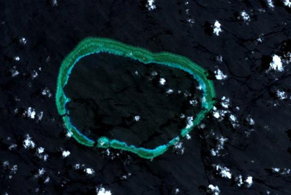 |
2011年3月24日
Carps among the Spratlys 南沙群岛的争战
订阅:
博文评论 (Atom)


没有评论:
发表评论